Burnett Mary
Burnett Mary
The Burnett Mary Region encompasses a land area of more than 56,000 km2, a marine area of almost 10,000 km2 and supports a population of over 200,000 people. The region is comprised of a number of catchments including the Baffle Creek, Kolan, Burnett, Burrum and Mary Rivers1. Only the northern most catchment of the Burnett Mary region, the Baffle Basin, is within the GBR and includes the tidal mudflats and mangroves in Rodds Peninsula/Turkey Beach considered ‘near pristine’.
Principal land uses in the Burnett-Baffle area are beef cattle grazing (the largest though currently declining), small crop growers, forestry (including plantations), tourism and fishing3. Other significant land uses include conservation, rural and urban residential development4.
Located in the northern section of the region is Rodds Bay, where freshwater input is minor from seasonal flows in small catchments, and water quality generally good - little organic/inorganic pollution even though Rodds Harbour has elevated natural turbidity and minor increases in sediment loads from grazing and development5.
The southern region includes the Mary River catchment (9181km²) and although outside the GBR Marine Park, is highly connected through oceanographic processes and plays a major driver of southern GBR ecosystems6. Grazing predominates and utilises 42% of the land area of the Mary catchment. High rainfall areas to the south and east host the majority of residential development, horticulture, and intensive livestock. Forestry and nature conservation, each of which occupies 18% of the catchment, are the second largest land uses, with intensive anthropogenic uses (residential, manufacturing, services, waste treatment, transport, and services) occupying 13% of the catchment area7. Sediment, total nitrogen and total phosphorus exports from the Mary catchment to the coastal receiving waters are estimated to be 455 kt.yr-1, 1.541 kt.yr-1 and 0.344 kt.yr-1, respectively8. Since European settlement, relative erosion rates in some sections of the Western Mary have increased 2 to 7 fold, and 4 to more than 14 fold in the Upper Mary9.
Seagrass in the region were first broadly surveyed in 198810 with the section north of Rodds Peninsula resurveyed at a finescale in 200211. Seven seagrass species have been reported in the Burnett Mary NRM region12, five within the marine park boundary13. Meadows have been reported throughout the inlets protected from the south easterly winds and oceanic swell, and throughout Hervey Bay and the Great Sandy Strait.
Very little seagrass has been mapped on the exposed coastline between Bustard Head to just north of Hervey Bay. Within the GBRWHA boundaries, the majority of seagrass meadows are within coastal and estuary habitats. South of the GBRWHA boundary in one of the largest single areas of seagrass resources on the eastern Australian seaboard12. The southern marine area of the Burnett Mary NRM region includes large meadows in deepwater, coastal (including intertidal and shallow subtidal) and estuarine habitats12.
Meadows in the north of the Burnett Mary region generally face low levels of anthropogenic threat, and monitoring sites are located within Rodd’s Bay. The only other location that is monitored within this region is in the south, at Urangan (Hervey Bay). This location is adjacent to the Urangan marina and in close proximity to the mouth of the Mary River.
Estuarine habitats occur in bays that are protected from the south easterly-winds and consequent wave action. The seagrasses in this area must survive pulsed events of terrestrial run-off, sediment turbidity and drops in salinity. Estuary seagrasses in the region are susceptible to temperature related threats and desiccation due to the majority being intertidal.
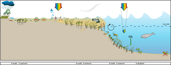
Conceptual diagrams of seagrass habitat in Burnett Mary Region
Estuarine seagrass habitats tend to be intertidal, on the large sand/mud banks in sheltered areas of the estuaries. The seagrasses in this area must survive pulsed events of terrestrial run-off, sediment turbidity and drops in salinity. Estuary seagrasses in the region are susceptible to temperature related threats and desiccation due to the majority being intertidal. Estuary seagrasses are highly susceptible to impacts from local industry, Urangan Marina and inputs from the Mary River.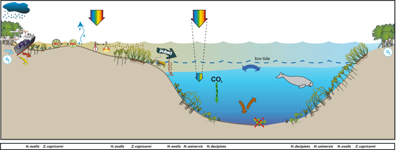
Marine Monitoring Program
2019 -2020 Summary
Inshore seagrass meadows across the Burnett–Mary NRM region changed little in overall condition in 2019–20, with the index score remaining in a POOR grade. The scores of abundance and reproductive effort decreased marginally, nutrient status increased but the grades for each remained unchanged.
Contributing indicators to the overall score were:
- abundance score was poor
- reproductive effort score was very poor
- tissue nutrient score was poor.
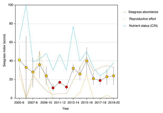
Seagrass abundance decreased marginally overall, but there are location-specific variations in the trends in the region. Abundances increased at Rodds Bay and Burrum Heads, but abundance and meadow extent declined further at Urangan.
The persistent seed banks coupled with improved abundances in meadows in the estuarine habitats in the north of the region may indicate an improved resilience; however reproductive effort continues to remain very low across estuarine habitats, possibly limiting replenishment of seed bank.
In late 2019, seagrass leaf tissue nutrient concentrations and ratios continue to indicate surplus availability of N to photosynthetic C incorporation in estuarine and coastal meadows; from natural N-fixation rather than anthropogenic sources. Although N availability may be high, it does not appear to have influenced epiphyte and macroalgae abundances which remain low across the region.
The marginal increase in Burnett–Mary region seagrass condition index in the 2019–20 continues from increases in 2018–19, following the declines in 2016–17 and 2017–18, from the highest score in 10 years, and was driven by increases in the nutrient status indicator.
Within seagrass canopy water temperatures
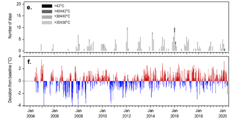
Within-canopy temperatures in 2019–20 were warmer than the previous year and slightly above the long-term average. Maximum intertidal within-canopy temperatures exceeded 35°C for a total of 13 days during 2019–20, with the highest temperature recorded at 40.9°C (UG2, 2pm 07Mar20).
Long-term monitoring Results:
Climate and Environmental pressures 2019-2020: 20
During 2019–20, rainfall and river discharge in the Burnett–Mary region were below average. But despite this, monitoring sites were exposed to turbid water, predominantly ‘brown’ turbid water for 100 per cent of the wet season.
- Within-canopy light was lower than the long-term average for the region as a whole. However, due to relocation of RD2 to RD3 and the recent addition of light monitoring to the Burrum Heads sites, it is difficult to assess trends in light levels at this time.
Sediments in the estuary seagrass habitats of the Burnett–Mary region are generally dominated by mud. In 2019–20, the proportion of mud increased in the meadows in the south of the region, after experiencing a period of increased sands in 2018–19. Meadows in the north remained relatively stable, albeit with seasonal variability. Coastal meadows in 2019–20 continued to be dominated by fine sand with little change from the previous year.
Inshore seagrass and habitat condition: 20
- In the 2019–20 monitoring period, the Burnett–Mary region seagrass condition index remained largely unchanged and rated as a poor grade. The index remains well below the 2015–2016 level (which was the second highest on record) due to trends in all of the indicators.
- Over the long term, seagrass abundance regionally has fluctuated greatly (e.g. periods of loss and subsequent recovery). Increases between 2012 and 2016 were largely due to large increases at Urangan, which have since declined, while abundances at other locations have steadily increased. The long-term trend suggests that where losses have been observed, they are not part of a declining trend.
- Reproductive effort remained low and rated as very poor in 2019–20. Reproductive effort is generally low in the region, but occasional large increases have occurred in 2008–9 and 2015–16.
Seagrass abundance, composition and extent: 20
- Seagrass abundances (per cent cover) across the Burnett–Mary region in 2019–20 were greater in coastal than estuarine habitats (15.2 ±0.6 per cent and 5.8 ±1.5 per cent, respectively), however estuarine abundances were higher in the late dry than the late wet season (10.2 ±2.0 per cent and 1.4 ±0.3 per cent, respectively). Half of the monitoring sites decreased in abundance in 2019–20 relative to the previous period, while only a third increased. Only one of the estuarine meadows in Rodds Bay remained stable in 2019–20.
- Since monitoring was established, the estuarine meadows have come and gone on an irregular basis. The only site to significantly decline over the long-term, was in the north of the region in the Rodds Bay estuary (RD2), however this decline was due to changes in the intertidal bank topography which rendered the site no longer suitable for ongoing monitoring, and the site has been discontinued. In the south, despite recent declines, both an estuary and a coastal site have significantly increased over the long-term, while no trend is apparent at the remaining monitoring sites.
- The estuarine and coastal seagrass habitats have remained dominated by Zostera muelleri with varying components of Halophila ovalis. In 2019–20, the proportion of colonising species increased at estuarine meadows compared to the previous monitoring year, but conversely continued to decline well below the Reef long-term average in coastal meadows. An increase in the proportion of colonising species in the meadows suggests some level of physical disturbance which may reduce ability to tolerate/resist major disturbances in future.
- Over the last 12 months, meadow spatial extent has remained stable at coastal meadows relative to the previous year. Estuarine meadows, however, continued to decline slightly in extent. This decline was restricted to meadows in the south (Urangan) which have fluctuated greatly with periods of decline, absence and recovery over the life of the MMP.
Seagrass reproductive status: 20
- Seagrass reproductive effort in the dry season increased for the first time this year at coastal habitats since assessments commenced, but were not as high at estuarine sites compared to the previous monitoring period.
- A seed bank persists at all meadows monitored across the region, which was slightly greater at estuary sites in 2019–20 than the previous period. This may indicate the meadows have a greater capacity to recover from the declining abundances, provided conditions are favourable.
- The apparent disconnect between reproductive effort and seed densities may be an artefact of the sampling frequency and the somewhat stochastic triggers and possibly short flowering period.
Epiphytes and macroalgae: 20
- Epiphyte cover on seagrass leaf blades in 2019–20 remained higher than the long-term average for the sixth consecutive year at estuarine habitats.
- Alternatively, at coastal habitats, the epiphyte abundance has remained below the long-term average for the fourth consecutive year).
- % cover of macroalgae has remained low and below the long-term average at across the habitats monitored), with the exception of a slight increase in estuarine habitats in the late wet of 2019.
Location
Rodds Bay
Monitoring: ongoing, biannual
Principal watchers: Seagrass-Watch HQ
Location: on large intertidal mud banks out from Turkey Beach
Site code: RD1, RD2, RD3
Issues: Land runoff
Comments: intertidal banks are extremely muddy
STATUS
- Seagrass abundance has significantly declined at all sites in Rodds Bay and the meadows remain in a Poor state
- Meadows are generally dominated by Zostera muelleri, however recent declines have seen an increase in the proportion of the colonising species Halophila ovalis.
- Seagrass canopy height (leaf length) is correlated to seagrass abundance.
- Macroalgae and epiphyte abundance is consistently low
- using the southern GBR seagrass guidelines values, seagrass state was determined for each monitoring event at each site by scoring the median values relative to the percentiles.
- seagrass abundance at both RD1 and RD2 declined after 2008 and has remained in a poor state since.
- RD3 established in 2017, after RD2 was discontinued. Changes in the intertidal bank topography at RD2, rendered the site no longer suitable for ongoing monitoring, and the site has been discontinued.
Seagrass cover, species composition and canopy height
Seagrass Cover: Timeseries of seagrass cover. Mean and standard error of site level observations shown. Timing of impacts attributed to acute disturbance events (Tropical cyclones) are indicated by vertical lines and disturbance symbol ֎ . Lower case "s" after site code, denotes subtidal sites.
Seagrass Composition: Mean composition of each seagrass species during each sampling event.
Plots are interactive with mouse-over features providing additional detail.
Location
Round Hill Creek
Monitoring: ongoing
Principal watchers: Gidarjil Land and Sea Country Rangers
Location: at the mouth of Round Hill Creek
Site code: RH1
Issues: urban development, stormwater & land runoff, boat traffic. Insufficient data to determine abundance guidance thresholds.
Seagrass cover, species composition and canopy height
Location
Burrum Heads
Monitoring: ongoing, biannual
Principal watchers: Seagrass-Watch HQ
Location: adjacent to the mouth of the Burrum River on the western shore of Hervey Bay
Site code: BH1, BH2, BH3
Issues: urban development, stormwater & land runoff, boat traffic
Comments: dugong and turtle feeding grounds

STATUS
- seagrass abundance at Burrum Heads is currently in a Poor state
- Burrum Heads seagrass meadows were impacted by two severe flooding events in early 2022; the first in early January and the second in late February.
- Seagrass cover has fluctuated over the last 20 years. After sites were established in 1999, cover increased at all sites from 2002, reaching peaks between 2003 and 2007, after which cover declined and fluctuated (decreasing and subsequently increasing) over the next 7 years.
- The dominant seagrass species at Burrum Heads include the opportunistic and colonising species Halodule uninervis (narrow leaf morphology) and Halophila ovalis, respectively. The dominance of these species indicates regular disturbance across most of the intertidal banks. The persistent species Zostera muelleri ssp. capricorni is more common at BH2, and a large dense meadow is present immediately seaward.
- Macro-algae abundance is generally low with episodic blooms, epiphytes appear to increase over late winter and spring then dramatically decline over summer months.
- Dugong feeding trails are commonly found at Burrum Heads (BH1) and are most abundant in May and August.
- Polycheate worms are common but gastropods were relatively scarce. The abundance of polychaetes may be due to high supply of detrital matter, a known food source. Gastropods not only scavenge detrital matter but some graze on seagrass leaves, and some are predatory in their feeding habit. The paucity of gastropods in seagrass meadows may due to low seagrass abundance (i.e. less grazing matter and associated faunal prey).
- Seagrass canopy height (leaf length) changes seasonally, reaching minima mid-year and maxima over the summer months.
- Polycheate worms are common but gastropods were relatively scarce. The abundance of polychaetes may be due to high supply of detrital matter, a known food source. Gastropods not only scavenge detrital matter but some graze on seagrass leaves, and some are predatory in their feeding habit. The paucity of gastropods in seagrass meadows may due to low seagrass abundance (i.e. less grazing matter and associated faunal prey).
Seagrass cover, species composition and canopy height
Location
Dundowran
Monitoring: ongoing, biannual
Principal watchers: Greg Lynch
Occasional and past watchers: Seagrass-Watch HQ
Location: on the large intertidal banks on the western coastline of Hervey Bay
Site code: DD1, DD2, DD3
Issues: urban development, stormwater & land runoff
Comments: dugong and turtle feeding grounds

STATUS
- seagrass abundance at Dundowran has remained in a Poor state since monitoring was established in 1999
- seagrass cover has remained low, with significant increases (followed by declines) at DD3 in late 2007, late 2011 and late 2014.
- the decline in seagrass cover from August 1999 to May 2000 at most intertidal sites between Burrum Heads and Dundowran was due to burial by mobile sediments.
- seagrass species composition has remained stable, with the infrequent appearance of Zostera muelleri ssp. capricorni from time to time at DD2 and DD3.
- The dominant seagrass species include the opportunistic and colonising species Halodule uninervis (narrow leaf morphology) and Halophila ovalis, respectively. The dominance of these species indicates regular physical disturbance across the intertidal banks
- Algae and epiphytes occasional episodic blooms – generally in middle of the year.
- Sediment grain size has become slightly coarser across all sites over the monitoring period.
- Polycheate worms are common but gastropods were relatively scarce. The abundance of polychaetes may be due to high supply of detrital matter, a known food source. Gastropods not only scavenge detrital matter but some graze on seagrass leaves, and some are predatory in their feeding habit. The paucity of gastropods in seagrass meadows may due to low seagrass abundance (i.e. less grazing matter and associated faunal prey).
- The sites are influenced by wave action and tidal flows with high sediment movement observed throughout the monitoring period. A likely cause for changes in epiphyte and macroalgae cover at some sites (DD2 and DD3) is possibly a consequence of elevated nutrients from agricultural lands and sewage outlets (e.g. Eli Creek).
Seagrass cover, species composition and canopy height
Location
Hervey Bay
Monitoring: ad hoc
Past watchers: Seagrass-Watch HQ, QPWS Great Sandy Marine Park
Location: central Hervey Bay, subtidal sites in 10-23m depth
Site code: HV1, HV2, HV3, HV4, HV5, HV6, HV7
Issues: agricultural land and urban runoff
Comments: legacy sites, originally assessed in November 1988 (Lee Long et al., 1992), and again between December 1992 and January 1994 (Preen et al., 1995). Included within Seagrass-Watch on 11 December 1998 (McKenzie 2017). Meadows support dugong and green sea turtle population within the Great Sandy Marine Park.
STATUS (August 2011)
- seagrass abundance within Hervey Bay was last assessed in August 2011. Current state is unknown.
- In January and February 2022, two large flood events from the Mary and Burrum Rivers, extended into the waters of Hervey Bay. Seagrass abundance across intertidal locations declined (see Urangan and Burrum Heads), but the status of the deeper water meadows is unknown.
- Since the first assessment in 1988, seagrass in Hervey Bay has been impacted by a number of severe climatic events (storms and associated floods), in particular 1992, 1999 and 2011. The 1992 events resulted in the the loss of around 1,000km2 of seagrass, which recovered within 1-2 years. Similarly, losses in 1999 recovered within 9 months to 2 years.
Seagrass cover, species composition and Macroalgae
Data priot to 1998 should be interpreted with caution as not fully compliant with Seagrass-Watch QAQC
Location
Toogoom
Monitoring: archived
Past watchers: Maree Cliff, Ian McLaren & Jen Holt, Mark Burnham, Jen Holt, Lauren Curry, Wendy Jones, Robin McLaren & Seagrass-Watch HQ
Location: On the western coastline of Hervey Bay
Site code: TG1, TG2, TG3
Issues: urban development, stormwater & agricultural land runoff
Comments: dugong and turtle feeding grounds
STATUS (June 2010)
- seagrass abundance at Toogoom was in a Poor state when last examined in June 2010
- seagrass abundance at TG1 has remained stable between years over the monitoring period. Within years seagrass abundance appears to follow a seasonal pattern with slightly higher abundances in the middle of the year from late winter to spring.
- seagrass abundance at TG3 had not recovered to mid 1999 values. Seagrass was showing some seasonal trends in abundance, with significant increases each spring.
- The dominant seagrass species included Halodule uninervis (narrow leaf morphology) and Halophila ovalis. Species composition varied over the monitoring period with losses of both Zostera muelleri ssp. capricorni and H. uninervis due to sediment burial.
- algae was generally low with occasional episodic blooms
- epiphytes increased dramatically in late 2002 and early 2003, however these declined.
- Sediment grain size remained stable with fine sands.
- The sites are influenced by wave action and tidal flows with high sediment movement observed throughout the monitoring period. A likely cause for change in seagrass cover at some sites (TG2, TG3) was smothering by sand movement and scouring by water channels.
Seagrass cover, species composition and canopy height
Location
Urangan
Monitoring: ongoing, biannual
Principal watchers: Seagrass-Watch HQ
Past watchers: Trischelle Lowry, Matt Lowry, Karen Kirk, Kathy Maskey, Natalia Gleeson, Greg Lynch, Di-anne Duffield, Star of the Sea, Sue Olsson, Wendy Jones, David & Rhonda Kohler, Moyra McRee, Paul Evans, & Jerry Comans
Location: immediately south of the marina and 14.5km north of the Mary River mouth
Site code: UG1, UG2
Issues: urban development, worm digging, sewerage treatment, stormwater, marina development & land runoff
Comments: dugong and turtle feeding grounds

STATUS
- seagrass at Urangan is currently in a Poor and vulnerable state
- Urangan seagrass meadows were impacted by two severe flooding events from the Mary River in early 2022; the first in early January and the second in late February.
- Seagrass abundance has fluctuated greatly at Urangan since monitoring was established in 1999. The Urangan meadow has come and gone on an irregular basis. Following a major flood in February 1999, seagrass was absent from August 1999 to May 2000. Seedlings of Zostera muelleri ssp. capricorni appeared in July 2000, and meadow recovery took 2-3 years. This cycle of loss and recovery was repeated from 2006 to 2008, and again in 2011 to 2015. At the end of 2017, the meadows once again declined significantly in abundance and extent, and little recovery was observed until 2021.
- Percentage cover of macroalgae has continued to remain low. Algae cover is relatively insignificant at these sites, although blooms occur at irregular intervals.
- Epiphyte cover on seagrass leaf blades at Urangan were high and variable over the years of monitoring, however has been gradually increasing since 2009, suggesting chronic elevated nutrients.
- Sediment grain size has changed relatively little over the monitoring period.
- Dugong feeding was absent until late 2001, coinciding with seagrass recovery. Feeding trails are regularly observed across the meadows.
- The high abundance of gastropods may be due to high amounts of mud and organic detrital matter in the sediments. Polychaete worms were also abundant.
Seagrass cover, species composition and canopy height
Location
Booral
Monitoring: archived
Past watchers: Trischelle Lowry, Matt Lowry Horst Pfaller, Paul Hatherell, Chris Ashcroft, Brooke & Jemma Donahay, Lynn Child and Seagrass-Watch HQ
Location: 2.5-6.5km south of Urangan and mid-way to River Heads (the mouth of the Mary River)
Site code: UG3, UG4
Issues: urban development, stormwater & land runoff
Comments: dugong, turtle and shorebird feeding grounds
STATUS (May 2008)
- seagrass abundance at Booral was in a Poor state when last examined in May 2008
- seagrass abundance increased significantly in 2002, but declined in 2005 and not significantly different than was observed when the site was established in late 2000.
- episodic macroalgae blooms occurred in late 2001 and 2002, however the algal abundances subsequently declined early in the new year.
- Epiphyte abundance is positively correlated with seagrass abundance.