Fitzroy
Fitzroy
The region covers ten percent of Queensland’s land area and is home to approximately 200,000 people. It is one of the richest areas in the state in terms of land, mineral and water resources and supports grazing, irrigated and dryland agriculture, mining, forestry and tourism land uses2. Agricultural production constitutes the largest land use in Central Queensland, with nearly 90 per cent of the land under agricultural production. Concomitant with this land use is concern of the quality of the water that is entering the GBR lagoon.
The Fitzroy region experiences a tropical to subtropical humid to semi arid climate. Annual median rainfall throughout the region is highly variable, ranging from about 800 mm to over 1000mm. Most rain falls in the summer, with many winters experiencing no rain at all. Because of the tropical influence on rainfall patterns, heavy storms can trigger flash flooding, and occasional cyclones wreak havoc.
The first broad scale survey of seagrass habitat in this region occurred in 1987, followed by more fine scale surveys of Shoalwater Bay3, the Dugong Protection Areas of Llewellyn Bay, Ince Bay and the Clairview Region 4 and Port Curtis to Rodds Bay5. Ten species of seagrass have been recorded from this region ranging from the intertidal to a depth of 48m 6,7.
The majority of seagrass in this region exist on large shallow banks flats. Expansive meadows exist on the coastal intertidal flats of Ince Bay, Clairview, Shoalwater Bay and Rodds Bay. The area of shallow subtidal coastal seagrass habitat in this region is small, as most of the coastline is exposed to south-east winds6. A significant factor contributing to the lack of suitable coastal habitat is the scouring tidal currents and associated high water turbidity in this region which limits light penetration and therefore the depth to which seagrasses can grow. Deepwater seagrasses were generally not found in the central and northern parts of this region, apart from occasional sites in the lee of islands or reefs8.
MMP sites within this region are located in coastal, estuarine or fringing-reef seagrass habitats. Coastal sites are monitored in Shoalwater Bay and are located on the large shallow banks of the north western shores of Shoalwater Bay. The remoteness of this area (due to its zoning as a military exclusion zone) represents a near pristine environment, removed form anthropogenic influence. In contrast, the estuarine sites are located within Gladstone Harbour: a heavily industrialized port. Offshore reef sites are located at Monkey Beach, Great Keppel Island.
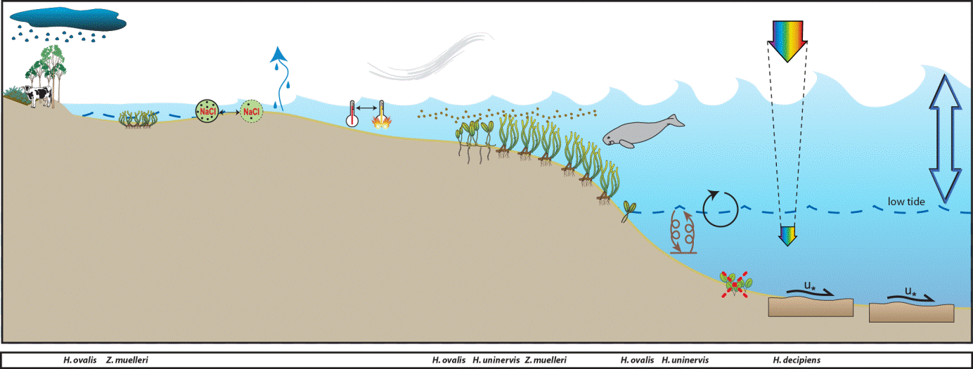
The Shoalwater Bay monitoring sites are located in a bay which is a continuation of a coastal meadow that is protected by headlands. A feature of the region is the large tidal amplitudes and consequent strong tidal currents. As part of this tidal regime, large intertidal banks are formed which are left exposed for many hours. Pooling of water in the high intertidal, results in small isolated seagrass patches 1-2m above Mean Sea Level (MSL).
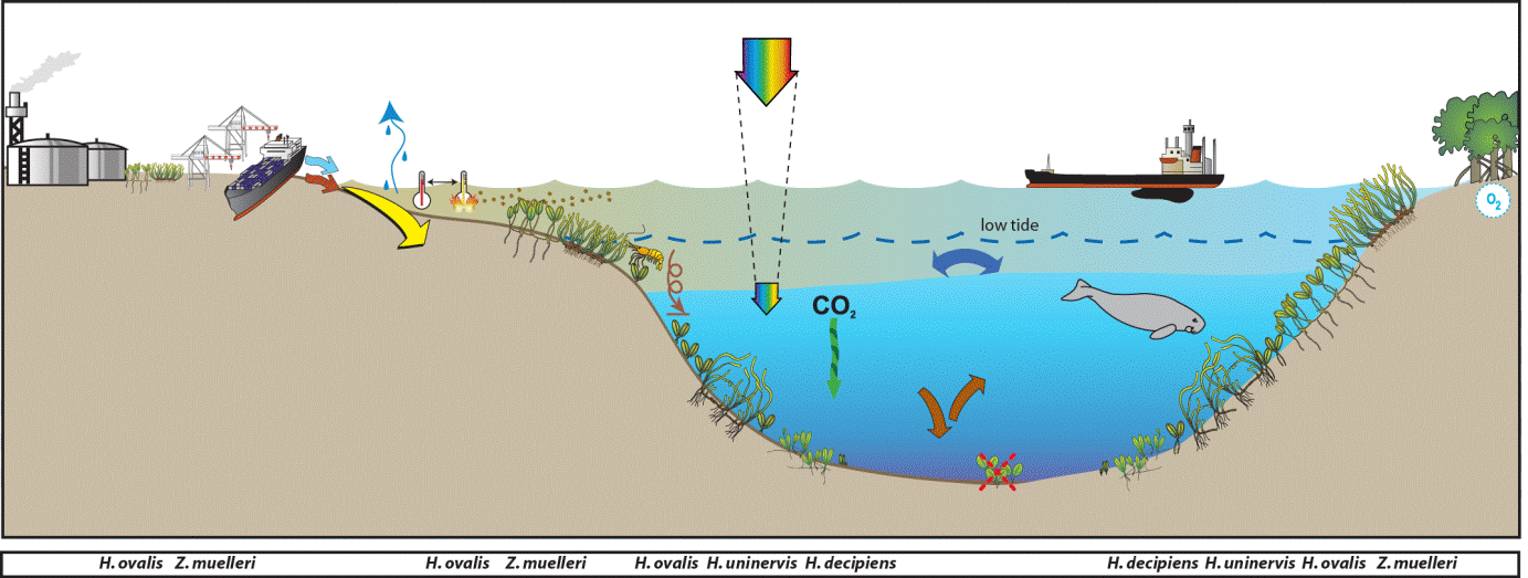
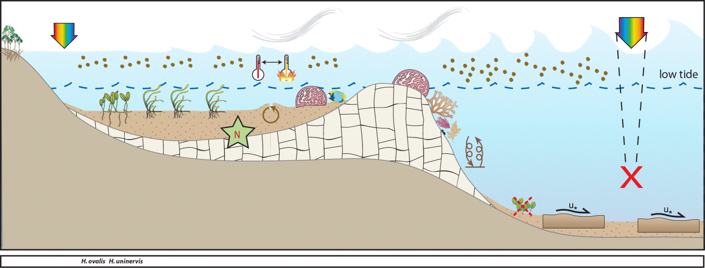
Conceptual diagrams of seagrass habitat in the Fitzroy region
MMP sites within this region are located in coastal, estuarine or fringing-reef seagrass habitats. Coastal sites are monitored in Shoalwater Bay and are located on the large shallow banks of the north western shores of Shoalwater Bay. The remoteness of this area (due to its zoning as a military exclusion zone) represents a near pristine environment, removed form anthropogenic influence. In contrast, the estuarine sites are located within Gladstone Harbour: a heavily industrialized port. Offshore reef sites are located at Monkey Beach, Great Keppel Island.
in the southern Fitzroy region tend to be intertidal, on the large sand/mud banks in sheltered areas of the estuaries. Tidal amplitude is not as great as in the north and estuaries that are protected by coastal islands and headlands support meadows of seagrass. These habitats feature scouring, high turbidity and desiccation (linked to this large tide regime), and are the main drivers of distribution and composition of seagrass meadows in this area. These southern estuary seagrasses (Gladstone, Port Curtis) are highly susceptible to impacts from local industry and inputs from the Calliope River. Port Curtis is highly industrial with the world’s largest alumina refinery, Australia’s largest aluminium smelter and Queensland’s biggest power station. In addition, Port Curtis contains Queensland’s largest multi-cargo port (Port of Gladstone) with 50 million tonnes of coal passing through the port annually.
Marine Monitoring Program
2019 -2020 Summary
Overall, the Fitzroy regional seagrass condition score remained graded as POOR in 2019–20.
There were no substantial changes from the previous year in any of the indicators, where the:
- abundance score was poor
- reproductive effort score was very poor
- tissue nutrient score was poor.
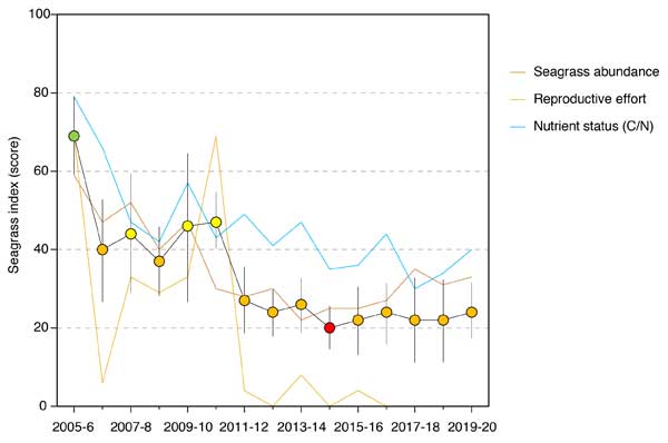
All sites, except in the estuarine habitat, reduced in abundance in 2019–20. Abundances at the coastal intertidal sites in Shoalwater Bay declined in 2019–20 after a period of near record high levels. Estuarine habitat abundance remains very low, after a wave of mud and burrowing shrimp activity moved through the area, but is showing signs of recovery. Abundances remain very low at the reef intertidal sites, with little variability among years except in the degree of fragmentation as shown by the seagrass extent. However, a reduction in the proportion of colonising species in 2018–19 indicates that the reef meadows have been relatively stable. The long-term trend in the seagrass abundance score across the region is largely unchanged over the past few years.
Reproductive effort remains well below historical peaks for all habitats in the region. However, the consistent presence of some reproductive structures and a persistent seed bank in both coastal and estuarine habitats indicates some resilience and capacity to recover from any future events. Of concern is that reproductive effort at reef sites remains very low to absent, and there is no seed bank despite an increase in the proportion of H. uninervis, a species that can contribute to the seed bank.
Within seagrass canopy water temperatures
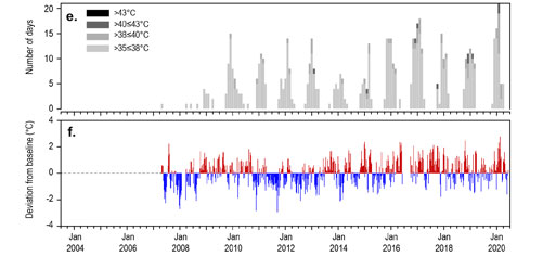
2019–20 within-canopy temperatures were similar to the previous period and the long-term average. Maximum intertidal within-canopy temperatures exceeded 35°C for a total of 63 days during 2019–20, with the highest temperature recorded in the region at 40.5°C (RC1, 3pm 06Feb20). Daily tidal exposure was above the long‐term average in 2019–20 for the second period in four years, which may have exacerbated stresses experienced at intertidal sites.
Long-term monitoring Results:
Climate and Environmental pressures 2019-2020: 20
Rainfall and river discharge in 2019–20 were below the long-term average for the Fitzroy region. Exposure of inshore seagrass to turbid waters during the wet season was similar, albiet slighty higher, than the long-term average, with the coastal and estuarine sites exposed to highly turbid ‘brown’ water in most weeks. By contrast, the reef sites were exposed to predominately ‘green’ water which has lower light attenuation.
Annual within-canopy light availability was higher in 2019–20 than both the previous period and the long-term average for the region (Figure 9, Figure 70). The most notable change in benthic light levels occurred at Shoalwater Bay, where benthic light levels (15.5 mol m-2 d-1) were below the long-term average (18.4 mol m-2 d-1). But despite this, light levels at Shoalwater Bay were the highest among all sites in the region because they are very shallow and frequently expose to full sunlight. Daytime tidal exposure was less than the previous period but remained above the long-term average for the region, which increases the risk of desiccation stress, but in the turbid shallow waters can provide windows of light for photosynthesis.
Inshore seagrass and habitat condition: 20
- In the 2019–20 monitoring period, the seagrass condition index remained relatively stable and was graded as poor.
- The abundance score increased marginally on average, but remained poor.
- Reproductive effort has remained low since 2011–2012 and scored very poor in 2019–20 for the seventh year in a row. Therefore, fluctuations in the seagrass condition index over the last seven monitoring periods have been primarily driven by fluctuations in abundance and tissue nutrient status.
- Tissue nutrient elemental C:N increased slightly in 2019–20, but remained on the grade threshold of poor.
Seagrass abundance, composition and extent: 20
In 2019–20, coastal and reef sites declined in abundance relative to the previous period, however, this was offset by the estuary sites where one site (GH1) doubled in abundance and the other site remained stable. Seagrass abundances (per cent cover) in the Fitzroy region in 2019–20 were significantly higher in coastal (18.2 ±0.7 per cent) and estuarine (11.2 ±1.8 per cent) habitats, than reef (0.5 ±0.3 per cent). Seagrass abundances across all habitats were higher in the late dry than the late wet season (e.g. coastal 25.2 ±0.7 per cent and 11.2 ±0.7 per cent, respectively).
Seagrass abundance at estuary and coastal intertidal habitats has fluctuated greatly between years over the life of the monitoring, with some sites experiencing total or near total loss followed by recovery. In 2019–20, all but one of the coastal sites decreased in abundance relative to the previous period, but the increase at GH2 was enough to slightly elevate the score for the region.
Examination of the long-term trend in seagrass abundance (per cent cover) across the region reveals a significant decrease. These decreases have primarily occurred in the estuary and reef habitats, although two thirds of all monitoring sites in the region (including coastal) show no significant trend.
Seagrass abundance in the estuarine habitat — believed to be low due to a legacy of a mud wave traversing across the meadow — is showing signs of recovery at GH2, leading to a general increase in abundance for the habitat type. As the mud wave dissipated in 2018–19, meadow integrity (e.g. reduced scarring) improved.
In the north of the region, coastal sites receive low river discharge, however, the meadows were still exposed to turbid ‘brown’ sediment laden waters for much of the year. There turbid waters could be partly the result of wind-driven resuspension, but appear mainly the consequence of the extreme tidal movement in Shoalwater Bay (some of the highest along the Queensland coast).
Seagrass reproductive status: 20
- Reproductive effort has varied inconsistently among habitats in the Fitzroy region over the life of the MMP. Reproductive effort is higher in the late dry season and remained steady at coastal and estuary sites in 2019–20. A seed bank has also persisted at coastal and estuary sites since 2012.
- Reproductive effort has remained very low at reef sites and were absent in 2019–20 together with the seed bank. This limits the meadow capacity to recover following further disturbance.
Epiphytes and macroalgae: 20
Epiphyte cover on the leaves of seagrass in estuarine habitats of the Fitzroy region increased in 2019–20 to above the overall inshore Reef long-term average for the first time in four years. At coastal habitats, however, epiphyte abundances continued to fluctuate and at reef habitats remain below the overall inshore Reef long-term average for the seventh consecutive year.
Macroalgae cover remained very low and below the overall inshore Reef long-term average at all habitats in the Fitzroy region, with a minor deccrease at the reef habitat.
Shoalwater Bay
Shoalwater Bay is located in the southern section of the Great Barrier Reef Marine Park World Heritage Area. The Shoalwater Bay Area covers 520 000 ha, of which approximately 50 % is marine. There is relatively little human disturbance (coastal towns and development, etc.) and it is a largely intact natural system. The region includes the most important dugong site in the southern GBR (classified as a special unique site) and is a significant wetland (classified as a Ramsar site and green turtle foraging site). Shoalwater Bay is a Dugong Protected Area (DPA), declared in January 1998 to protect key dugong (Dugong dugon) populations and habitat. The Shoalwater Bay region DPA has an ‘A’ level of protection prohibits commercial net fishing to protect dugong from entanglement in some fishing nets, as they forage and move (see GBRMPA)
Shoalwater Bay supports several inshore fishing industries, however the low fish production in the area is largely for reasons to do with the remoteness of the region and access problems posed for both recreational and commercial fishers, rather than low fish abundance. Seagrass in the Shoalwater Bay are considered regionally important as nursery habitats for species of commercial and recreational fishing value (e.g., western king prawns and true endeavor prawns) and as feeding area for dugongs and green sea turtles. The Shoalwater Bay area supports the largest dugong population between Cooktown and Hervey Bay and is considered the most important dugong habitat in the GBR region south of Cape York. Shoalwater Bay also supports the largest known feeding concentration of the southern Great Barrier Reef genetic stock of green turtles. Tens of thousands of individuals feed on the seagrass meadows and fringing reefs of the area.
Seagrass meadows in and around Shoalwater Bay were first mapped during a broad scale survey in 1987 and large areas of patchy and dense seagrass were found on the shallow banks within the bay.
In 1995/1996, approximately 13,000 ha of seagrass habitat were mapped in the bay9. Eight species (from 3 families) of seagrasses exist in the bay and most seagrass habitats are located on soft substrates and mostly restricted to intertidal flats. A few subtidal meadows do occur in the north eastern waters of the bay. The area of subtidal seagrass habitat in Shoalwater Bay is small. Strong tidal currents and associated high water turbidity in Shoalwater Bay limit light penetration and therefore the depth to which seagrasses can grow. Seagrasses are present at depths from 0.7 m above MSL to 8.2 m below MSL.
The major seagrass habitats in the region are estuarine and coastal.
Location
Shoalwater
Monitoring activity: Ongoing
Principal watchers: Seagrass-Watch HQ
Location: intertidal banks approximately 500m NW of the mouth of Ross Creek. Wheelans Hut sites are approximately 2.5km west of Sabina Point
Site codes: RC1, RC2, WH1, WH2, WH3
Issues: freshwater and sediment runoff from the land
Comments: Due to Department of Defence restrictions, access to seagrass habitats are limited. Sites are in seagrass meadows frequented by green turtles and dugong.
Both sites are dominated by Zostera mulleri to various degrees with Halodule uninervis and Halophila ovalis comprising a common but less abundant component of the seagrass. Cymodocea serrulata was observed occasionally. It should be noted that percent compositions prior to February 2004 were not quantitative.
WH1 and WH3 are dominated by Zostera mulleri to various degrees with Halodule uninervis and Halophila ovalis comprising a common but less abundant component of the seagrass. WH2 (Sabina Pt) was dominated by Halodule uninervis and the substrate was predominately sand. Cymodocea serrulata was observed occasionally. Precent compositions prior to February 2004 were not quantitative.
Sabina Point seagrass meadow (WH2) showed a sudden and rapid decline in seagrass between February 2004 and June 2004. Seagrass abundance declined from approximately 20% to less than 5%. This meadow is a naturally disturbed site (indicated by the prevalence of ripples in the sand) and was dominated by Halodule uninervis (a colonizing species). The site is also sandier than the other sites and sediment disturbance as a consequence of wind and waves was the likely cause of the decline. Associated with the sediment disturbance, was anecdotal reports of increased sedimentation and subsequent changes to the topography of the intertidal banks. This may have resulted in longer periods of exposure to desiccation. Also during this period, the location experienced extreme elevated temperatures. A combination of all these factors would have contributed to the observed declines. In late 2005 the abundances began to increase. Whether abundances have returned to values similar to when monitoring was established is unknown.
Seagrasses in Shoalwater Bay are able to persist on the large intertidal banks, where periods of shallowing water provide some respite from the highly turbid waters. However, these periods of shallowing water and carbon limitation (when exposure to air coincides with low spring tides) not only stress plants with desiccation, but also fluctuating water temperatures.
Maximum water temperatures exceeded 35°C for a total of 57 days in Shoalwater Bay during 2019–20, with a highest temperature of 40.5°C. The high temperatures are particularly stressful for Z. muelleri communities which dominate the coastal habitats as it has a thermal optima for overall net primary productivity of 24°C and above 35°C net productivity goes into deficit, i.e. it loses energy. This is in stark contrast to other tropical species (H. uninervis and C. serrulata), which must exceed 40°C for respiration rates and photoinhibition to cause the plants to lose energy for pulsed exposure. 21.
Coastal meadows in Shoalwater Bay (Ross Creek and Wheelans Hut) had an increased proportion of colonising species (H. ovalis) after 2011 but remained dominated (>0.5) by the opportunistic species Z. muelleri and H. uninervis. In 2019–20, the proportion of these opportunistic species increased at both the coastal and estuarine sites which continued to be dominated by Zostera muelleri. Colonising species, however, continued to dominate the reef habitat sites (well above the overall inshore Reef long-term average), which appears a direct relationship with decreased abundances over the last few years.
The extent of the coastal meadows within monitoring sites in Shoalwater Bay has changed little since monitoring commenced in 2005. The extent of the estuarine meadows has fluctuated since 2016 when there was a large reduction in one of the sites due to extensive scarring and sediment deposition. This year the sediment deposition abated and the meadow was showing signs of recovering, e.g. shoot extension and improved meadow cohesion. Conversely, meadows on the reef flat at Great Keppel Island remained highly fragmented after the 2016 losses and show little sign of recovery, e.g. unstable sediments.
Seagrass cover, species composition and canopy height
Seagrass Cover: Timeseries of seagrass cover. Mean and standard error of site level observations shown. Timing of impacts attributed to acute disturbance events (Tropical cyclones) are indicated by vertical lines and disturbance symbol ֎ . Lower case "s" after site code, denotes subtidal sites.
Seagrass Composition: Mean composition of each seagrass species during each sampling event.
Plots are interactive with mouse-over features providing additional detail.
Location
Great Keppel
Monitoring: ongoing
Principal watchers: Seagrass-Watch HQ
Location: sites are located in Monkey Beach, Great Keppel Island
Site code: GK1, GK2
Issues: Land runoff
Comments: The meadows are on the intertidal sand banks at the southern end of the bay.
Seagrass cover and species composition
Seagrass cover, species composition and canopy height
Seagrass Cover: Timeseries of seagrass cover. Mean and standard error of site level observations shown. Timing of impacts attributed to acute disturbance events (Tropical cyclones) are indicated by vertical lines and disturbance symbol ֎ . Lower case "s" after site code, denotes subtidal sites.
Seagrass Composition: Mean composition of each seagrass species during each sampling event.
Plots are interactive with mouse-over features providing additional detail.
Gladstone
The Gladstone region extends from the Keppel Islands in the north, to Rodds Bay in the south. The estuarine Gladstone Harbour (Port Curtis) includes the fifth largest export port in Australia, and is presently the focus for rapid industrial expansion. The largest city in the region is Gladstone, with a population of approximately 29,288 (2006 estimate).
The Gladstone region contains significant areas of high value seagrass including extensive meadows of species important for dugong as well as high fisheries value nursery meadows5. The region contains a Dugong Protection Area and is known to support significant populations of dugong and turtle.
Extensive coastal intertidal to shallow subtidal (< 5m below mean sea level) seagrass communities are found throughout the harbour area from the Narrows in the north to Rodds Bay in the south.
7246 ±421 ha of coastal seagrass habitat was mapped in November/December 20025. Most intertidal seagrass meadows are dominated by Zostera capricorni and these are widely distributed throughout the region. Z. capricorni often occur in conjunction with Halophila ovalis to form both light and moderately abundant mixed species communities. Z. capricorni communities most commonly occur as aggregated patches on the extensive intertidal mud and sand banks located throughout the area.
Meadows dominated by Halodule uninervis (wide and thin leaf morphology) are the second most widely distributed and occur in two main areas: in the north, on the intertidal sand / mud banks between Quoin and Facing Islands; and in the south, on the shallow subtidal regions along the exposed coasts of Boyne, Wild Cattle and Hummock Hill Islands. Minor coastal seagrass habitats include subtidal Halophila ovalis and H. decipiens communities located adjacent to Fisherman’s Landing Wharves in the north and intertidal H. ovalis dominated communities further south in Rodds Bay. Halophila spinulosa dominates two communities at the mouth of Seven Mile Creek in Rodds Bay and also forms a minor component of other subtidal meadows throughout the survey area. Shallow subtidal meadows are dominated by Halophila and are found immediately adjacent to the mud and sand banks.
Approximately 6,332 ha of deepwater seagrass (>5m below MSL) are also found offshore from Facing Island and around Seal Rocks, West Banks and East Banks. Deepwater seagrass meadows are dominated by low abundance Halophila species with some Halodule uninervis. The maximum depth recorded for offshore seagrass was a Halodule spinulosa meadow at 19.1m below mean sea level5.
Seagrasses in the Gladstone area face significant threats from a range of sources. Gladstone contains substantial port and industrial infrastructure including existing and proposed reclamations, capital dredging, industrial and urban discharges, regular maintenance dredging and port and marine facility expansion. Two rivers, the Boyne and Calliope, also discharge into the harbour with potential non point source pollution from catchment use a threat to seagrasses. The largest river in the region is the Fitzroy River which discharges into Keppel Bay, north of Gladstone Harbour.
Location
Gladstone Harbour
Monitoring: ongoing, biannual
Principal watchers: Seagrass-Watch HQ
Location: northern and southern sections of Pelican Banks, 1 km from public boat ramp at Southend (Curtis Island)
Site code: GH1, GH2
Issues: Land runoff and industrial/port development
Comments: Extensive Zostera muelleri meadows on stable sand bank. Dugong feeding trails common.
Seagrass cover, species composition and canopy height
Seagrass Cover: Timeseries of seagrass cover. Mean and standard error of site level observations shown. Timing of impacts attributed to acute disturbance events (Tropical cyclones) are indicated by vertical lines and disturbance symbol ֎ . Lower case "s" after site code, denotes subtidal sites.
Seagrass Composition: Mean composition of each seagrass species during each sampling event.
Plots are interactive with mouse-over features providing additional detail.