Burdekin
Burdekin
The Burdekin region, includes an aggregation of the Burdekin, Don, Haughton and Ross River catchments and several smaller coastal catchments, all of which empty into the Great Barrier Reef lagoon1. Rainfall is lower than other regions within tropical Queensland with an annual average of approximately 1,150 mm from on average 91 rain days. There is, however, considerable year-to-year variation due to the sporadic nature of tropical lows and storms. Approximately 75 per cent of the average annual rainfall is received during December to March2.
Approximately 18 per cent of the seagrass area mapped in the shallow waters (<15m) of the GBR occurs in the Burdekin NRM region 3. Intertidal seagrasses and shallow subtidal seagrasses dominate in this region, the majority of which are within coastal habitats4. Extensive seagrass meadows occur in Upstart, Cleveland, and Bowling Green Bays and off Magnetic Island. Twelve species have been found within this region5,6. Deep water (>15m) seagrasses occur in this region but are not as common or dense as occurs in regions further north7. Most fringing reefs associated with continental islands support moderately dense mixed species meadows (especially Cymodocea serrulata), which are not restricted to the confines of fringing reefs, but are also found in sheltered bays at continental islands or coastal localities4.
Major threats to seagrass meadows in the region include: coastal development (reclamation); changes to hydrology; water quality declines (particularly nutrient enrichment or increased turbidity); downstream effects from agricultural (including sugarcane, horticultural, beef), industrial (including refineries) and urban centres2,8. All four generalised seagrass habitats are present within the Burdekin region, and MMP monitoring occurs at coastal and reef seagrass habitat locations.
The coastal monitoring sites are located on naturally dynamic shallow sand banks and are subject to sand waves and erosion blowouts moving through the meadows. The Townsville (Bushland Beach and Shelley Beach) area is a sediment deposition zone, so the meadow must also cope with incursions of sediment carried by long shore drift. The Bowling Green Bay (Jerona) location is adjacent to the mouth of Barratta Creek. Sediments within this habitat are mud and sand that have been delivered to the coast during the episodic peak flows of the creeks and rivers (notably the Burdekin) in this area. While episodic riverine delivery of freshwater nutrients and sediment is a medium time scale factor in structuring these coastal seagrass meadows, it is the wind induced turbidity of the coastal zone that is likely to be a major short term driver. In these shallow coastal areas waves generated by the prevailing SE trade winds are greater than the depth of water, maintaining elevated levels of suspended sediments, limiting the amount of light availability for photosynthesis during the trade season. Another significant feature in this region is the influence of ground water9. The meadows are also frequented by dugongs and turtles as witnessed by abundant grazing trails and patches of cropping .
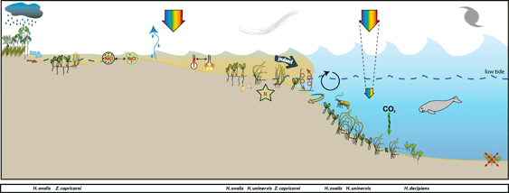
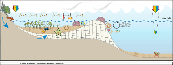
Conceptual diagrams of seagrass habitat in the Burdekin
Estuarine habitats within this region are in open estuaries/inlets and tend to be continuous with the coastal habitats. Both tidal and subtidal distributions are heavily influenced by their proximity to creeks and rivers. Delivery of freshwater and suspended solids, including clays, colloids, fine organic matter, is the major impact to all meadow types in this habitat. This influence extends beyond the estuarine zone during high flow events. Of the total sediment being delivered to the GBRWHA lagoon, the long term average discharge of sediment from this region represents 20%-40%. The major impact of terrestrial run-off on near-shore environments occurs during cyclones or heavy monsoonal rains and is only delivered during infrequent flooding events. Relatively low sediment discharge occurred over the intervening years. During flood events these habitats are subject to scouring, a combination of fast flow and course sediments. The habitats are productive nursery areas, particularly the southern parts of Cleveland and Bowling Green Bay as these are areas targeted by commercial and recreational fishers.
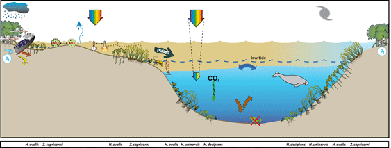
Coastal habitats are generally on naturally dynamic intertidal sand flats and are subject to sand waves and erosion blowouts moving through the meadows. While episodic riverine delivery of freshwater nutrients and sediment is a medium time scale factor in structuring these coastal seagrass meadows, it is the wind induced turbidity of the costal zone that is likely to be a major short term driver. In these shallow coastal areas waves generated by the prevailing SE trade winds are greater than the depth of water, maintaining elevated levels of suspended sediments, limiting the amount of light availability for photosynthesis during the trade season. Intertidal seagrasses can survive this by photosynthesizing during periods of exposure, but must also be able to cope with desiccation. Another significant feature in this region is the influence of ground water.
The reef habitats are mainly represented by fringing reefs on the many continental islands within this area. Most fringing reefs have seagrass meadows growing on their shallow banks. Nutrient supply to these meadows is by terrestrial inputs via riverine discharge, re-suspension of sediments and groundwater supply. The meadows are typically composed of zones of seagrasses: Cymodocea serrulata, Thalassia hemprichii and Halodule uninervis (wide leaf) often occupy the lower littoral/subtidal area, blending with Halodule uninervis (narrow leaved) and Halophila ovalis in the upper intertidal zone. Phosphate is often the nutrient most limiting to reefal seagrasses 10,11. Experimental studies on reef top seagrasses in this region however, have shown seagrasses to be nitrogen limited primarily with secondary phosphate limitation, once the plants have started to increase in biomass12 2003). In these fringing reef top environments fine sediments are easily resuspended by tidal and wind generated currents making light availability a driver of meadow structure.
Marine Monitoring Program
2019 -2020 Summary
- abundance score was poor
- reproductive effort score was poor
- tissue nutrient score was moderate.
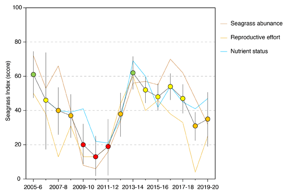
Seagrass abundance decreased relative to the previous period, due to declines in per cent cover at all sites, with the largest declines occurring in reef intertidal and subtidal habitats. The declines in abundance were likely the legacy from the 2019 wet season (previous reporting year) when losses occurred due to river discharge from the Burdekin River in concert with unusually large discharges from the smaller creeks and rivers entering Cleveland Bay. Sediment loads in the discharge and wind-driven resuspension elevated turbidity and reduced benthic light during the wet season, but light levels quickly returned to seasonally-expected levels. This is because environmental conditions in 2019–20 were relatively benign, with below-average rainfall and discharge, and temperatures around the long-term average.
Reproductive effort increased on average in 2019–20 compared to the previous reporting period elevating the score from very poor to poor; however, the patterns were inconsistent among habitat types. In coastal intertidal habitat reproductive effort declined in 2019–20 and was the lowest since 2014. In addition, the seed count in seed banks was very low for the sites, but higher than typical seed densities in the Reef. Reproductive effort remianed very low in reef intertidal and subtidal habitats. In all habitats seed density was higher in the late dry, but declined in the late wet, suggesting loss to germination, which is not uncommon but was particularly clear in 2019–20. If seedlings are present, abundances are expected to increase due to vegetative growth in the next year.
The tissue nutrient indicator score has fluctuated within a moderate range since 2014–15. In 2019–20, there were small increases in C:N in all habitats. This appears primarily a consequence of nitrogen content in leaves decreasing relative to carbon at all habitats, which may be likely associated with reallocation to growth, as the plants begin to recover from previous losses.
Over the past decade, seagrass meadows of the Burdekin region have demonstrated high resilience particularly through their capacity for recovery. This may reflect a conditioning to disturbance (high seed bank, high species diversity), but also reflects the nature of the disturbances which are episodic and dominated by wind events and Burdekin River flows.
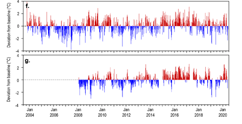
Within seagrass canopy water temperatures
Intertidal and subtidal within-canopy temperatures were similar to the previous period and the long-term average. Maximum intertidal within-canopy temperatures exceeded 35°C for a total of 47 days during 2019–20, with the highest temperature recorded at 39.8°C (JR1, 3pm 07Mar20).
Maximum subtidal temperature during 2019–20 was 33.8°C (5pm, 15Feb20). Daily tide exposure was similar to the long‐term average but below the long-term median at all sites, which may have provided some respite from the elevated temperatures.
Long-term monitoring Results:
Climate and Environmental pressures 2019-2020: 20
- Inshore seagrass sites in the region have a very high frequency of exposure to turbid waters during the wet season and they are the highest among all regions.
- In 2019–20, exposure to turbid water (classes 1–5) remained at 100% of wet season weeks at all sites i.e. all sites monitored throughout the region were exposed to ‘brown’ or ‘green’ turbid water for the entire wet season.
- Coastal sites (BB, SB and JR) experienced the highest exposure to ‘brown’ turbid, sediment laden, waters (100 per cent of wet season weeks categories 1–4), which is slightly higher than long-term average (94–99).
- By contrast, reef sites at Magnetic Island were exposed predominately to ‘green’, phytoplankton rich waters for most of the wet season weeks, and there was less exposure to ‘brown’ water at reef sites compared to average.
- Daily light levels in the Burdekin region were 10.9 mol m-2 d-1 on average in 2019–20, and therefore above the threshold thought to support optimal growth of 10 mol m-2 d-1.
- The largest increase in daily incident light occurred at Shelley Beach, where light was 1.7 mol m-2 d-1 higher than average, owing to a large rise in light levels in the late dry season.
- The only site with lower than average light levels, was Jerona.
- Intertidal and subtidal within-canopy temperatures were similar to the previous period and the long-term average (Figure 52). Maximum intertidal within-canopy temperatures exceeded 35°C for a total of 47 days during 2019–20, with the highest temperature recorded at 39.8°C (JR1, 3pm 07Mar20).
- Maximum subtidal temperature during 2019–20 was 33.8°C (5pm, 15Feb20).
Inshore seagrass and habitat condition: 20
- An additional coastal location, Bowen, was included in 2019–20. This location was previously monitored as part of the Seagrass-Watch global seagrass observing network from 2007 to 2012, but resumed in 2019 due to returned capacity and is planned to continue for the forseable future.
- In the 2019–20 monitoring period, the seagrass condition index for the Burdekin region increased slightly, but remained poor. The grade appears a legacy of the previous monitoring periods, which, as a result of the influence of region-wide above average wet season rainfall and river discharge, have carried over into the 2019–20 reporting period. Conversely, the reproductive effort and tissue nutrient status increased in 2019–20.Examination of indicators contributing to seagrass condition over the long-term, show declines from 2009–2011 as a consequence of the years of above-average rainfall and severe weather, proceeded by rapid recovery. Based on those previous trends, the seagrass meadows in 2019–20 would appear to be in a vulnerable state and at risk of further decline, but the presence of reproductive structures (albeit at low numbers) and a seed bank, indicates some capacity to recover depending on conditions.
Seagrass abundance, composition and extent: 20
- Seagrass abundance in the Burdekin region has shown a pattern of loss and recovery. Between 2008–09 and 2010–11, losses occurred as a result of multiple consecutive years of above-average rainfall (river discharge) and severe weather (cyclone Yasi). From 2011, seagrass rapidly recovered, however since 2014, seagrass abundance has progressively declined at reef (intertidal and subtidal) habitats. In 2018–19, the largest declines occurred in reef subtidal and coastal intertidal habitats, while in 2019–20 all of the Burdekin region sites declined in abundance with largest declines at reef intertidal and subtidal sites.
- An examination of the long-term abundances across the Burdekin region indicates no significant trend (from first measure to 2019–20), although significant trends were detected at two of the five coastal sites. One site (SB2), which has been monitored for nearly two decades (since 2001), showed a decreasing trend . The other site (JR2), near Jerona (Barratta Ck, Bowling Green Bay), has only been monitored since 2012, and not surprisingly showed a significant increasing trend in abundance, as this coincides with the main recovery period after the regional losses. A significant long-term decline occurred at Cockle Bay, Magnetic Island (reef intertidal, MI2) since monitoring began in 2005.
- This year, as it has been since 2014–2015, a low proportion of species displaying colonising traits are present in all habitats (e.g. Halophila ovalis). Instead these habitats are dominated by opportunistic species (H. uninervis, Z. muelleri, C. serrulata) in coastal and reef sites or persistent species in intertidal reef habitat (T. hemprichii). Opportunistic and persistent foundation species also have a capacity to resist stress (survive, through reallocation of resources) caused by acute disturbances, and therefore, current species composition provides greater overall resilience in Burdekin meadows. However, the presence of colonising species is important for recovery following loss. Given the declines in seagrass abundance over the past few years, there may be an increase in the proportion of colonising species during future surveys.
- Meadow spatial extent declined to the lowest level recorded in reef subtidal habitats, in what appears to have been an ongoing legacy of the flood events in early 2019. By contrast, intertidal reef meadows increased in extent in 2019–20, following declines experienced in the last reporting period due to a proliferation of scarring and fragmentation. Meadow extent similarly increased in intertidal coastal meadows in 2019–20 after a period of slight decline but with a large variation in this response among sites as shown through the large standard errors.
Seagrass reproductive status: 20
- Reproductive effort is highly variable across Burdekin region habitats, particularly in coastal habitats where very high and anomalous levels of reproductive effort can occur, usually at times when abundance is also very high.
- In 2019–20, reproductive effort remained very low in coastal and reef intertidal habitats, in what appears to be a lag effect of the 2019 floods. Seed density in the seed banks of these habitats is also declining, likely due to seed germination following disturbances and declines in abundance, as well reduced replenishment. At reef subtidal habitats there was an increase in reproductive effort in 2019–20 from zero in the previous year.
- Seed densities sharply declined in the post-wet season presumably due to germination, but will hopefull be replenished through sexual reproduction.
Epiphytes and macroalgae: 20
- Epiphyte cover was above the overall inshore Reef average in both seasons (2019–20) and at the highest level since 2004. However, in reef intertidal habitat, epiphyte loads were lower than the overall inshore Reef average, and in reef subtidal habitats epiphytes were seasonally variable, being higher in the wet season.
- Macroalgae abundance has remained low and below the long-term average at coastal habitats, where there is limited substrate for establishement. Macroalage was high and reached record levels in reef intertidal habitats, but remained low in subtidal habitats.
Location
Townsville
Monitoring: ongoing
Principal watchers: Seagrass-Watch HQ
Location: on the large inter tidal sand bank in front of Cape Pallarenda and Bushland Beach township, between the Bohle and Black Rivers
Site code: BB1, SB1, SB2
Issues: Coastal development, land runoff
Comments:
The Bushland Beach area is a sediment deposition zone, so the meadow must also cope with incursions of sediment carried by long shore drift. The meadows are frequented by dugongs and turtles as witnessed by feeding trails. These meadows are also visited regularly by recreational fishers. Sediments within this habitat are mud and sand that have been delivered to the coast during the episodic peak flows of the creeks and rivers (notably the Burdekin) in this area.
The Shelly Beach area is a sediment deposition zone, so the meadow must also cope with incursions of sediment carried by long shore drift. The meadows are frequented by dugongs and turtles as witnessed by feeding trials and scars. Sediments within this habitat are mud and sand that have been delivered to the coast during the episodic peak flows of the creeks and rivers (notably the Burdekin) in this area.
Seagrass cover, species composition and canopy height
Seagrass Cover: Timeseries of seagrass cover. Mean and standard error of site level observations shown. Timing of impacts attributed to acute disturbance events (Tropical cyclones) are indicated by vertical lines and disturbance symbol ֎ . Lower case "s" after site code, denotes subtidal sites.
Seagrass Composition: Mean composition of each seagrass species during each sampling event.
Plots are interactive with mouse-over features providing additional detail.
Location
Magnetic Island
Monitoring: ongoing
Principal watchers: Seagrass-Watch HQ
Location:
MI1:intertidal fringing reef flat in the north of Picnic Bay, adjacent to the wreck (MI1).
MI2: Fringing reef flat in the eastern corner of Cockle Bay, adjacent to the excavated boat harbour
Site code: MI1, MI2, MI3 (Subtidal)
Issues: Coastal development, ground-water seepage, land runoff, boat and pedestrian traffic.
Comments: Picnic Bay is fringed by coral reefs on its seaward edge and has seagrass growing on its intertidal flat and subtidally, beyond the reef crest. The seagrass meadow at this location is multispecific with stands of Cymodocea serrulata with Thalassia hemprichii, Halophila ovalis (lower intertidal, subtidal), Halodule uninervis (wide) (middle intertidal) and Halophila ovalis/Halodule uninervis (narrow) occupying the upper intertidal region. Patches of Syringodium isoetifolium (shallow subtidal) and Nanozostera muelleri (intertidal) have also been observed within this meadow. Cymodocea rotundata has also been previously recorded from this meadow. Within the Seagrass-Watch site Halodule uninervis(narrow) /Halophila ovalis with Nanozostera muelleri almost encroaching on Transect 1.
Hermit crabs, sesarmid crabs, Astropecten starfish are quite abundant within the site with the occasional dugong feeding trail.
Sea turtle feeding area. Large number of stingrays present. The seagrasses at Cockle bay form an extensive, multi-specific, fringing reef flat meadow. Species found within this meadow include Halophila ovalis, Halodule uninervis, (narrow and wide leaved morphologies) Cymodocea serrulata, Thalassia hemprichii and, recently, a patch of Syringodium isoetifolium has been observed.
Seagrass cover, species composition and canopy height
Seagrass Cover: Timeseries of seagrass cover. Mean and standard error of site level observations shown. Timing of impacts attributed to acute disturbance events (Tropical cyclones) are indicated by vertical lines and disturbance symbol ֎ . Lower case "s" after site code, denotes subtidal sites.
Seagrass Composition: Mean composition of each seagrass species during each sampling event.
Plots are interactive with mouse-over features providing additional detail.
Location
Bowling Green Bay
Monitoring: ongoing
Principal watchers: Seagrass-Watch HQ
Location: Adjacent to the mouth of Barratta Creek
Site code: JR1, JR2
Issues: Coastal development, runoff
Comments: The meadows are also frequented by dugongs and turtles as witnessed by abundant grazing trails and patches of cropping
Seagrass cover, species composition and canopy height
Seagrass Cover: Timeseries of seagrass cover. Mean and standard error of site level observations shown. Timing of impacts attributed to acute disturbance events (Tropical cyclones) are indicated by vertical lines and disturbance symbol ֎ . Lower case "s" after site code, denotes subtidal sites.
Seagrass Composition: Mean composition of each seagrass species during each sampling event.
Plots are interactive with mouse-over features providing additional detail.
Location
Bowen
Monitoring: ongoing (MMP)
Principal watchers: Jacquie Shiels, Heather Marshall, Shenna Barrett, Elmer Ten-Haken
Location: intertidal banks off Front Beach
Site code: BW1, BW2, BW3
Issues: increasing vessel use, anchor impacts
Comments: important foraging habitat for green sea turtles and dugongs.
Seagrass cover, species composition and canopy height
Location
Edgecumbe Bay
Monitoring: ongoing ad hoc
Principal watchers: Gudjuda Land & Sea Rangers, Seagrass-Watch HQ
Location: intertidal banks Edgecumbe Bay
Site code: EB1
Issues: increasing land impacts
Comments: important foraging habitat for green sea turtles and dugongs.
Location
Sandfly Creek
Monitoring: suspended
Location: Southern shore of Cleveland Bay
Site code: SC1, SC2
Issues: Sewage treatment outfall, land runoff, coastal development
Comments: Fishing grounds, dugong and turtle feeding grounds. Nursery area for mud and sand crabs.
STATUS (June 2004)
- The sites have not been examined since 2004.
- Insufficient data to describe long-term trends, but early data indicated that abundances showed typical seasonal pattern (higher in late spring-summer than winter).
- Seagrass abundance at SC2 significantly decreased since mid-2002. Isolated patches of Nanozostera muelleri were in the vicinity.
- SC1 has always had low seagrass abundance and appears to have remained similar.
- Species composition appears unchanged over sampling period
- Canopy height slightly lower although not significant as highly variable
- Algae and epiphyte currently lower than expected, but not significant as highly variable. The seagrass and mangrove aerial roots were covered in filamentous algae in July 2004, but this seems to be widespread phenomena at this time of year.
- Sediment appears similar, although at present possibly less muddy
Seagrass cover, species composition and canopy height
Location
Rowes Bay
Monitoring: training/demonstration site
Location: Rowes Bay, Townsville
Site code: RB1, RB2
Issues: Downstream from estuarine creek, storm water and urban runoff, beach replenishment works.
Comments: The intertidal area of Rowes Bay includes several different marine habitats such as a mangrove forest, a rocky shoreline, a small muddy, coarser sandy and several rubbly reefal areas, one of which includes a tropical sponge garden on the seaward edge. Interspersed between and within all these habitats are seagrasses. Over the years this seagrass meadow has come and gone, clearly demonstrating the ephemeral nature of intertidal seagrass meadows. The Seagrass-Watch site is south-east of the estuarine creek and predominantly Halodule uninervis, interspersed with small amounts of Halophila ovalis. Macroalgae is also quite common within this site. This meadow is a highly disturbed site with regular pedestrian traffic, inputs of freshwater and associated sediment loads. Invertebrate diversity is high.
Seagrass cover, species composition and canopy height
Location
PALM ISLAND
Monitoring: archived
Location: Palm Island, Townsville
Principal watchers: Seagrass-Watch HQ
Location: on the inter tidal bank in front of Fred Clay Freedom Park (Palm Island)
Site code: PM1
Seagrass cover, species composition and canopy height
Location
LUCINDA
Monitoring: archived
Location: Lucinda, Halifax
Principal watchers: Seagrass-Watch HQ
Location: on the inter tidal Sand bank in front Lucinda
Site code: HX1
